
Keyword
Earth Science | Biological Classification | Animals/Invertebrates | Arthropods | Crustaceans | Decapods
159 record(s)
Type of resources
Topics
Keywords
Contact for the resource
Provided by
Formats
Update frequencies
Status
draft
-
The aims of the project were to provide managers with information and advice to facilitate sound management of the Torres Strait tropical lobster fishery, by undertaking stock assessment and biological research. The research outcomes contained in this document relate to phase 2 priorities arising from the Tropical Rock Lobster Fishery Assessment Group Workshop (TRLFAG) held on 29-30 March 2000. The Phase 2 priority research tasks include: analyses of the June 2001 survey data and of the available industry/management data, analysis of the size-frequency and catch-effort data collected in June 2001, the May/June 2002 full-scale absolute abundance field survey and the 2001-2002 stock assessment, which will be based on continued development of the dynamic model developed during Phase 1. The thirteenth annual lobster survey was completed in May/June 2002 as part of the full-scale Benchmark Survey. This annual report summarises activities undertaken since July 2001.
-
The aims of the project are to provide managers with information and advice to facilitate sound management of the Torres Strait tropical lobster fishery, by undertaking stock assessment and biological research. The research objectives include: annual population surveys; annual Islander catch monitoring, parameter estimation (growth, mortality and recruitment); and fisheries dynamics modelling. This annual report summarises activities undertaken since July 2000. The twelfth annual lobster survey was recently completed (June 2001), and preliminary analysis of data from this survey has been completed and results are reported here.
-
The initial conditions and carrying capacity estimates for the prawn stocks in NWS InVitro were calculated using catch data and biological information taken from the WA Department of Fisheries (2002) submission to Environment Australia regarding the Exmouth Gulf Prawn Fishery. This information was converted to total stock sizes using the assessment rule of thumb that catch at Maximum Sustainable Yield equals 12% of virgin biomass and cross checked using the methods outlined in Taylor and Dichmont (2001). This resulted in an upper bound on the estimate of maximum total biomass of 15000t for western king prawns, with a lower bound of 8000t and a median of 12000t. For the banana prawns the upper bound on biomass was again 15000t, but the lower bound was 4000t and the median was 8000t. All other prawn biological parameters were based on Kailola et al. (1993) and Taylor and Dichmont (2001).
-
Beam trawl surveys of juvenile prawns were carried out between the Vanderlin Islands and Rosy Creek, Gulf of Carpentaria to investigate the impact of dredging by MacArthur River Mines.
-
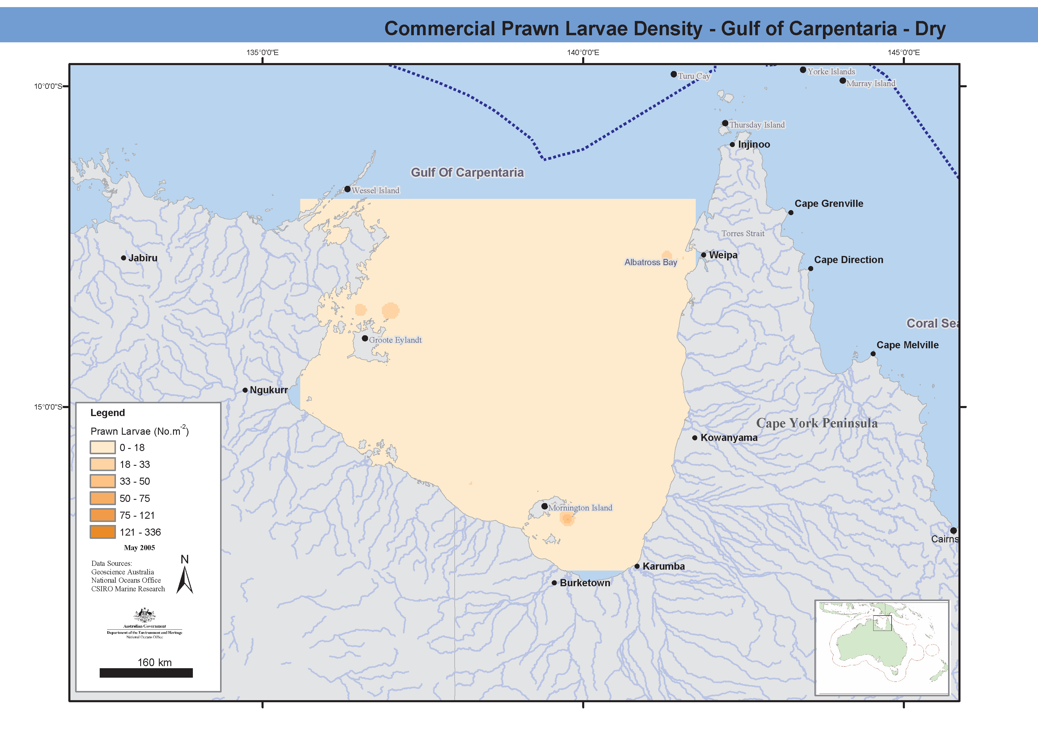
Maps showing prawn larval distribution of commercial prawn species during both the wet and dry seasons in Albatross Bay. The data was recorded from stepped oblique bottom to surface plankton tows, 140-142um nets. Nine cruises took place between 1975 and 1977 on chartered boats and the "Kalinda". Prawn larval biomass and densities were measured in several transects across the Gulf of Carpentaria, as well as total plankton biomass. These maps have been produced by CSIRO for the National Oceans Office, as part of an ongoing commitment to natural resource planning and management through the 'National Marine Bioregionalisation' project.
-
This dataset series comprises deck logs from the vessel "Rama" in which observations made during the Gulf of Carpentaria Prawn Survey are recorded. This survey was conducted jointly by the Queensland State and Commonwealth Governments during 1963-1965 to examine the prawn resources of the south-eastern corner of the Gulf of Carpentaria.
-
This dataset was collected to calculate optimal seasonal opening dates for the commercial fishery and to provide other management advice, by undertaking size sampling of pre-season and in-season banana prawns (F. merguiensis and F. indicus). In-season sampling of commercial catch on commercial trawlers (1983 - 1985) was supplemented during the season by data obtained from quality control staff at KFV Fisheries Pty Ltd. Sampling was organized for pre- and in-season searching and sampling voyages and prawns were sampled and measured from as many trawlers as possible.
-
Field experiments were carried out investigating prawn predation using tethering techniques at three sites in the Embley River in October 1994, December 1994 and April 1995.
-
The dataset comprises GIS grids of fishing effort of the Northern Prawn Fishery (NPF) estimated from vessel monitoring system (VMS) data. The VMS is operated by the Australian Fisheries Management Authority (AFMA). It periodically records the location of each vessel in the fishery. Note that the activity of the vessel at the time is not recorded. The system's primary purpose is to monitor compliance with fishing regulations, but the data can also be used for research. To estimate fishing effort from the VMS records, we estimated the track of each fishing vessel by joining successive vessel locations with lines. We divided the track into apparent trawling and non-trawling sections (e.g. based on date, time and vessel speed), and calculated the time each trawling section spent in each cell of a GIS grid covering the managed area of the fishery. This method for estimating fishing effort from VMS data has limitations. Because a vessel may have taken a path other than a straight line between the polls, our straight line path (a) may only partially match the real path of the vessel, (b) may underestimate the length of the path traversed by the vessel, and (c) may underestimate the speed of the vessel. Note that (a) and (b) would affect which particular grid cells the trawling time was allocated to, but not the total trawling time that was added to the grid. The use of vessel speed to filter out non-trawling activity is imperfect because vessels may carry out other activities at speeds less than the maximum trawling speed.
-
In 1997 and 1998, we tagged and released 18013 red-legged banana prawns in the Joseph Bonaparte Gulf. The location of recaptures was documented for 916 tagged prawns in 1997 and 512 tagged prawns in 1998. Tag recapture information and commercial fishery logbook information was used to test whether red-legged banana prawns moved continuously to deeper waters or whether they moved first to deep water but then returned to shallower waters. The analysis is based on compartment models of recaptures per unit of fishing effort.